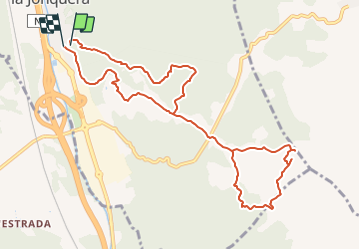
![](/images/other/stat-length.png)
![Randonnée A pied la Jonquera - Marxa dels dòlmens i ruta dels estanys - Photo](https://media.geolcdn.com/t/1900/400/fedcbff4-20db-4413-b792-cfa0f34dafa2.jpeg&format=pjpeg&maxdim=2)
Marxa dels dòlmens i ruta dels estanys
SityTrail - itinéraires balisés pédestres
Tous les sentiers balisés d’Europe GUIDE+
![Longueur](/images/other/stat-length.png)
![Altitude max](https://static1.geolcdn.com/siteimages/upload/files/1508320355ic_sort_altitude_max_24dp.png)
![Dénivelé positif](https://static1.geolcdn.com/siteimages/upload/files/1508320355ic_sort_den_pos_24dp.png)
![Km-Effort](/images/other/stat-length.png)
![Altitude min](https://static1.geolcdn.com/siteimages/upload/files/1508320355ic_sort_altitude_min_24dp.png)
![Dénivelé négatif](https://static1.geolcdn.com/siteimages/upload/files/1508320355ic_sort_den_neg_24dp.png)
![Boucle](https://static1.geolcdn.com/siteimages/upload/files/16400158638029165_repeat_loop_refresh_sync_direction_icon.png)
![A pied](https://static1.geolcdn.com/sitytour/trail-icons/100.png)
3h17
Difficulté : Facile
![Scannez ce code QR pour ouvrir la randonnée dans l'application SityTrail](https://capi.geolives.com/qq0zvz2zws4bq2lad0pu/sitytour/trails/3110493/qr.png?size=200)
Application GPS de randonnée GRATUITE
À propos
Randonnée A pied de 11,5 km à découvrir à Catalogne, Gérone, la Jonquera. Cette randonnée est proposée par SityTrail - itinéraires balisés pédestres.
Description
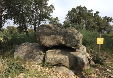
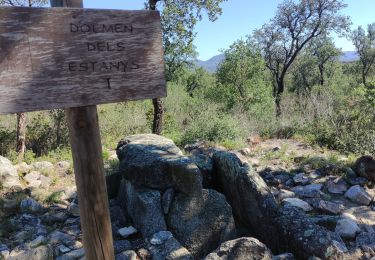
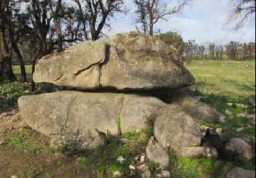
El Centre Excursionista Jonquerenc, organitza des de l’any 1983 la popular Marxa dels Dòlmens, senyalitzada en aquesta ruta. La zona humida dels estanys està inclosa dins el PEIN “Estanys de la Jonquera” i englobat dins els espais de la Xarxa Natura 2000
Site web: https://www.itinerannia.net/ca/itineraris/marxa-dels-dolmens-i-ruta-dels-estanys-ruta-15-alt-emporda/
Localisation
Commentaires
Randonnées à proximité
![Randonnée A pied Capmany - Itinerari megalític de Campmany - Photo](https://media.geolcdn.com/t/375/260/869eddc9-99f0-4850-9d15-c9f49ca84b69.jpeg&format=jpg&maxdim=2)
![A pied A pied](https://static1.geolcdn.com/sitytour/trail-icons/100.png)
A pied
![](/images/other/stat-length.png)
![](https://static1.geolcdn.com/siteimages/upload/files/16400158638029165_repeat_loop_refresh_sync_direction_icon.png)
![Randonnée A pied la Jonquera - PR-C 71 La Jonquera-Portbou - Photo](https://media.geolcdn.com/t/375/260/5e6d3380-2250-4b33-97db-8f0c01794288.jpeg&format=jpg&maxdim=2)
![A pied A pied](https://static1.geolcdn.com/sitytour/trail-icons/100.png)
A pied
![](/images/other/stat-length.png)
![](https://static1.geolcdn.com/siteimages/upload/files/16400158638029165_repeat_loop_refresh_sync_direction_icon.png)
![Randonnée Marche Le Perthus - penissar - Photo](https://media.geolcdn.com/t/375/260/db553a64-848c-49b3-ac51-caf4a414d04b.jpg&format=jpg&maxdim=2)
![Marche Marche](https://static1.geolcdn.com/sitytour/trail-icons/101.png)
Marche
![](/images/other/stat-length.png)
![](https://static1.geolcdn.com/siteimages/upload/files/16400158638029165_repeat_loop_refresh_sync_direction_icon.png)
![Randonnée Marche la Jonquera - CIRCUIT DES MÉGALITHES depuis EL FOGON - Photo](https://media.geolcdn.com/t/375/260/7a6e5bb6-23f5-4b50-857a-537a11402d8b.jpg&format=jpg&maxdim=2)
![Marche Marche](https://static1.geolcdn.com/sitytour/trail-icons/101.png)
Marche
![](/images/other/stat-length.png)
![](https://static1.geolcdn.com/siteimages/upload/files/16400158638029165_repeat_loop_refresh_sync_direction_icon.png)
![Randonnée Marche la Jonquera - 20230112 Site mégalithique- château Requesens - Photo](https://media.geolcdn.com/t/375/260/434ae223-eff4-4144-bd74-a07ff9e915d6.jpg&format=jpg&maxdim=2)
![Marche Marche](https://static1.geolcdn.com/sitytour/trail-icons/101.png)
Marche
![](/images/other/stat-length.png)
![](https://static1.geolcdn.com/siteimages/upload/files/16400158638029165_repeat_loop_refresh_sync_direction_icon.png)
![Randonnée Marche Le Perthus - palissades. la carboniere . fort de bellegrade . panissars - Photo](https://media.geolcdn.com/t/375/260/ed24b436-d9f9-4bce-9f3c-0eb2cbedcc4f.jpg&format=jpg&maxdim=2)
![Marche Marche](https://static1.geolcdn.com/sitytour/trail-icons/101.png)
Marche
![](/images/other/stat-length.png)
![](https://static1.geolcdn.com/siteimages/upload/files/16400158638029165_repeat_loop_refresh_sync_direction_icon.png)
![Randonnée Marche Le Perthus - Panissars_Fort-Belgarde - Photo](https://media.geolcdn.com/t/375/260/ext.jpg?maxdim=2&url=https%3A%2F%2Fservices.sitytrail.com%2FGeolivesWS%2FDownloadMedia.ashx%3FTrailID%3D572198%26Media%3Dfix__20160520173218.jpg)
![Marche Marche](https://static1.geolcdn.com/sitytour/trail-icons/101.png)
Marche
![](/images/other/stat-length.png)
![](https://static1.geolcdn.com/siteimages/upload/files/16400158638029165_repeat_loop_refresh_sync_direction_icon.png)
![Randonnée Marche Le Perthus - 66 LE PERTHUS - col de Panissars - GR10 - pistes - fort de Bellegarde - Photo](https://media.geolcdn.com/t/375/260/ext.jpg?maxdim=2&url=https%3A%2F%2Fservices.sitytrail.com%2FGeolivesWS%2FDownloadMedia.ashx%3FTrailID%3D473083%26Media%3D20150918174636.jpg)
![Marche Marche](https://static1.geolcdn.com/sitytour/trail-icons/101.png)
Marche
![](/images/other/stat-length.png)
![](https://static1.geolcdn.com/siteimages/upload/files/16400158638029165_repeat_loop_refresh_sync_direction_icon.png)
![Randonnée Marche Capmany - Capmany Mégalithique_2 - Photo](https://media.geolcdn.com/t/375/260/ext.jpg?maxdim=2&url=https%3A%2F%2Fservices.sitytrail.com%2FGeolivesWS%2FDownloadMedia.ashx%3FTrailID%3D304677%26Media%3D70129613-bd6d-4e80-a4c3-608884f2ea29.jpeg)
![Marche Marche](https://static1.geolcdn.com/sitytour/trail-icons/101.png)
Marche
![](/images/other/stat-length.png)
![](https://static1.geolcdn.com/siteimages/upload/files/16400158638029165_repeat_loop_refresh_sync_direction_icon.png)